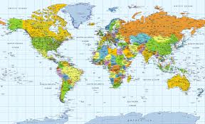
In this chapter you will be learning how to create many types of maps. There are political, general purpose, topographic, thematic, small scale, and large scale maps. You will also be learning the important elements of mapping. The important tasks in this chapter include the exploring of the atlus, introduction to Canada, locating countries, continents and oceans on a map, map scaling, and creating and reading contour lines. visit this site
In this chapter you will be learning about climate, landforms (physiography), human activity, soils, and vegetation. You will learn about the transform plate boundaries, convergent plate boundaries, and divergent plate boundaries, which are the three plate boundaries. You will also learn about the different kinds of rocks. The important tasks in this chapter include recognizing the difference between the concepts of physical geography, researching the National Parks, and understanding the various climate changes in each of the provinces of Canada. Visit this site and follow the 9th link on this page (Canadian Biodiversity Website)

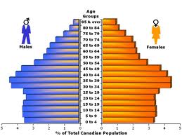
In this chapter you will be learning about Canada's population, the various population characteristics, and the population pyramid. The important tasks in this chapter include the studying of the population pyramid, and identifying and drawing the population characteristics. visit this site For more information on the content in this course visit this site